SPOKANE, Wash. — Heavy snow will be seen in parts of the Inland Northwest on Monday and Tuesday morning. But strong winds and a switch to rain could throw a major curveball into the ultimate snow forecast within the next 24 hours.
The snow is just beginning over Spokane as of 11 A.M. and is expected to increase in intensity during the evening hours. Temperatures got into the low 20s and teens Monday morning and now the ground is more than cold enough to support immediate snowfall accumulations everywhere (unlike Saturday morning). It's just a matter of how long the snow keeps falling before a switch to rain.
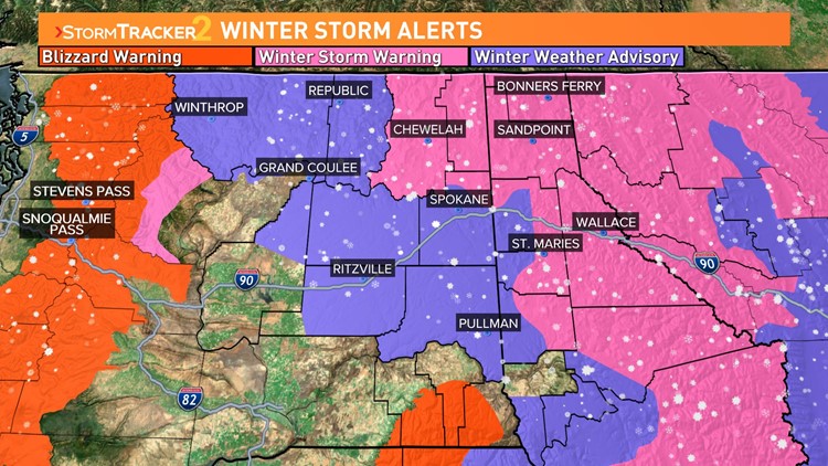
Winter Storm Warnings are in effect for Northeastern Washington until 10am Tuesday and for far North Idaho and the Silver Valley until 10am Wednesday.
Winter Weather Advisories are in effect for Spokane, Coeur d'Alene, Pullman, Ritzville, and Omak areas through 10am Tuesday.
The heaviest snow for eastern Washington will fall this evening before midnight. Meanwhile in North Idaho, the heaviest snow will be after midnight. The longer the snow continues into Tuesday will determine who will get the most snowfall overall.
For Spokane, 2-4" is the forecast as the snow will shut off after midnight as temperatures keep increasing and eventually the snow switches to rain. Meanwhile for Coeur d'Alene, the forecast of 3-7" is to account for a best chance of the precipitation staying as snowfall. In Sandpoint and Wallace, it'll be all snow and 6-12" is the forecasted snow totals.
The tricky part of the forecast is the aforementioned switch to rain. This occurs Tuesday morning as a warm push of air in the low level jet stream will push temperatures close to 38 to 40 degrees on Tuesday morning. This will certainly make it to Spokane County, but what's unclear is how far east will it go... Liberty Lake, Post Falls, Coeur d'Alene... this we won't know until it's happening.
What is clear is that the winds from this warm air will be strong. All of the Columbia Basin, including Spokane, is under a Wind Advisory Tuesday as wind gusts will be around 45mph. Locals off the foothills of the Blue Mountains, like Pomeroy, are under High Wind Warnings for expected wind gusts up to 60mph. The wind along with the heavy/slushy snow may cause power outages at times on Tuesday. Particularly if both are occurring simultaneously. Thankfully, those experiencing the worst of the wind will likely be the warmest and not receiving any further snowfall.
The one exception to this is the mountains and mountain passes. Both the Cascade range and the Blue Mountains are under Blizzard Warnings. A blizzard is the most severe winter weather criteria, only issued when white out conditions are imminent. The high winds and heavy snow will cause visibilities to drop to a quarter-mile or less for several hours. Which may cause mountain passes to become impossible to traverse. Snoqualmie Pass is almost certainly going to see closures. Be sure to check pass conditions, but it is strongly advised to just wait this storm out entirely.
The Blizzard Warning for Snoqualmie Pass going until 10am Wednesday. The Cascades will pick up 30-48" of snowfall in the next 48 hours.