SPOKANE, Wash. — Scattered thunderstorms across the Inland Northwest bring the threat of lightning, wind, and some heavy rain to the region. The storms, while not overly impressive, bring the threat of wildfires from lightning and locally gusty wind and some flooding in northern Washington and North Idaho.
Here's what alerts we have for the area and the time frame:
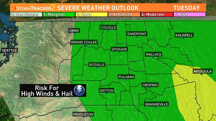
The Severe Weather Outlook is at a Marginal Risk for the entire Inland Northwest Tuesday. This means that damaging winds and hail are possible with the strongest thunderstorm cells today. Typically, "Marginal" means low on this nation-wide scale. The Storm Prediction Center's late-morning update even went so far as to put a "Slight" risk area near and south of Missoula, MT.
Should any thunderstorms start producing damaging winds or hail, the National Weather Service would issue a targeted "Severe Thunderstorm Warning" for induvial storm cells, warning those ahead of the storm 30 to 60 minutes in advance.
Flood Watches are in effect for north-central Washington until 11am Wednesday, and northeastern Washington and North Idaho until 5pm Wednesday. Heavy thunderstorm rains over poor drainage locations or burn scars could result in flooding between today and Wednesday morning.
Red Flag Warnings have been issued for Spokane, Pullman, Moses Lake, and surrounding areas in the upper Columbia Basin until 6pm today. Abundant lightning could pose a heightened fire risk today.
As for the timing, the first scattered storms fired up at 4am Tuesday, and will continue to random emerge for the rest of the afternoon. Unfortunately that's as precise as we can say before 6pm Tuesday. The short-term computer models give a final surge of more robust thunderstorm development after 6pm and through the night time. Between 6pm and 8pm should be our last way of strong or severe thunderstorms before a more steady rain finishes out the day and lasts through the night.
Wednesday morning, the rain will still be falling for most of the Inland Northwest, especially north of I-90. The westerly winds start to increase to 25-35 mph. A windy, rainy, and colder day is forecast Wednesday. But by this point, the intense energy is no longer present and thus severe thunderstorms are unlikely.
WATCH RELATED: Strong thunderstorms and flooding possible in many areas of the Inland Northwest on Tuesday


