
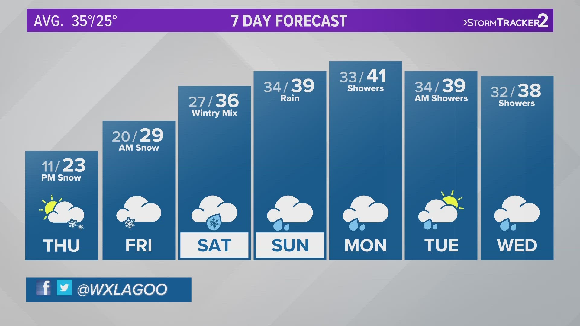
SPOKANE, Wash. — A potent storm will bring heavy snow to the Inland Northwest on the heels of our recent cold snap. The incoming storm looks to be the biggest snow maker of the season to date. The snow arrives Tuesday night and winter weather alerts are already in place in anticipation of the storm’s impacts.
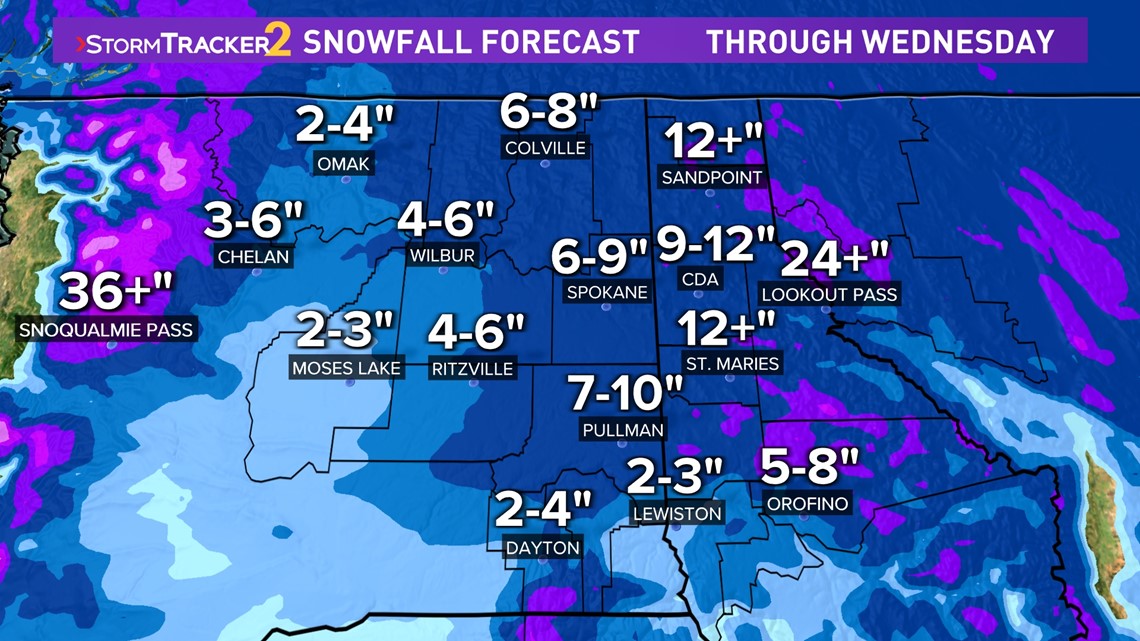
Winter Storm Warnings stretch from Spokane to the Canadian border in eastern Washington and encompass all of North Idaho. Valleys will pick up 6-12 inches of snow, mountains topping a foot by the time the snow stops falling Wednesday night. Winter Weather Advisories are in place for central Washington, where 2-4 inches of snow will pile up in places like Moses Lake and Ritzville.
Mountain passes will once again take the brunt of the storm. Winter Storm Warnings put 24-36 inches of snow over Snoqualmie and the Cascades Tuesday night through Wednesday. It is likely we will see major travel impacts out of this storm through the middle of the week.

The rising temperatures that accompany the incoming storm will be a double-edged sword for much of the Inland Northwest later this week. High temperatures will climb to near freezing on Wednesday with the warm air advection. The bump in temps will help thaw out much of the region, but the rising mercury brings the potential for sleet and freezing rain by the end of the week.
The second wave of energy hits Thursday night. With recent snow and cold, the rising temps will happen at a faster rate in the sky overhead than it does on the ground. As snow changes to rain, there is a potential for freezing rain in the Inland Northwest. It’s still far away and the forecast could change but Friday morning has the worst potential for ice formation.

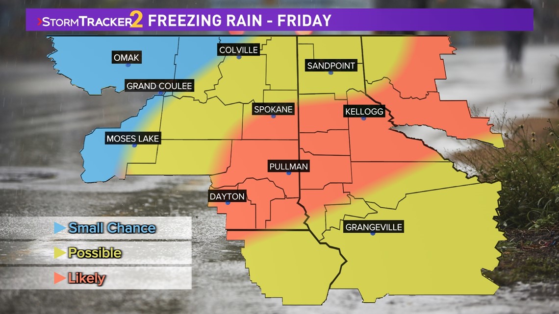
The greatest threat looks to be Spokane, but that will need to be updated after Wednesday’s snow. Either way, by the weekend, it will be warm enough that widespread rain falls below 4,500 feet. That means places like Spokane, Coeur d’Alene and the Palouse will have heavy rain falling on melting snow by early next week.
The warm weather looks to stick around through the end of January. While that doesn’t mean we are done with the cold and snow, it does likely mean we have seen the worst of winter by the time this week closes out.
WATCH RELATED: Snow falling across Spokane and North Idaho
DOWNLOAD THE KREM SMARTPHONE APP
DOWNLOAD FOR IPHONE HERE | DOWNLOAD FOR ANDROID HERE
HOW TO ADD THE KREM+ APP TO YOUR STREAMING DEVICE
ROKU: add the channel from the ROKU store or by searching for KREM in the Channel Store.
Fire TV: search for "KREM" to find the free app to add to your account. Another option for Fire TV is to have the app delivered directly to your Fire TV through Amazon.
To report a typo or grammatical error, please email webspokane@krem.com.