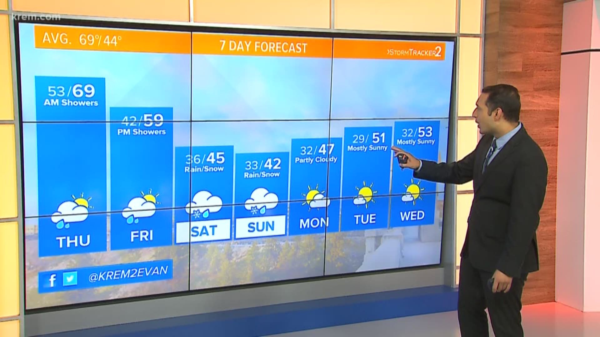
SPOKANE, Wash. — A Winter Storm Watch will be in effect for mountaintops and passes in northeast Washington and North Idaho as up to a foot of snow is expected in some areas.
Schweitzer Mountain Road, Mullan, Dobson Pass and Lookout Pass are under the Winter Storm Watch on Friday through Sunday. The National Weather Service is predicting between six inches to a foot of snow, with winds as high as 55 mph.
In Washington, the Highway 20 Wauconda Summit, Sherman Pass, Blewett Pass and Loup Loup Pass, among others, are also under the watch. These areas could see similar snow accumulations, with wind gusts as high as 45 mph.
The Idaho Transportation Department says its snowplows and drivers are prepared to clear highways if needed.
Cascades could see several inches of snow by Sunday
The Cascade Mountain Range across Washington state could see several inches of snow by Sunday, according to the Spokane office of the National Weather Service.
This could cause difficult travel conditions across Snoqualmie Pass and Stevens Pass from Friday through Monday.
A strong cold front will arrive over the weekend, bringing early morning and afternoon temperatures down significantly. Temperatures are trending about 20 degrees below average over the weekend.
Meteorologists say two inches of snow could fall over the eastern slopes of the Cascades from Friday into Saturday, with even more expected between Saturday and Sunday. Mountain ranges throughout the North Idaho Panhandle could also see accumulating snow.
The Washington State Department of Transportation recommends that drivers keep certain items in their cars in case of a winter weather emergency on the roads.
Those items include a full tank of gas, first aid kit, cell phone charger, flashlight, water and snacks, ice scraper and snow brush, jumper cables, flares, tire chains, and warm clothing.
WSDOT also advises that you check to see if you have traction tires and know what traction advisories are in place when on the road.
More winter driving tips are available on the WSDOT website.
Will the Spokane metro area see snow?
Confidence is low in any snow accumulating over the weekend for lowland and metro areas across eastern Washington or North Idaho. This means any snow that falls in Spokane and Coeur d'Alene will likely melt immediately.
Some cities may also see just rain or a rain snow mixture. All of this is dependent on how temperatures line up with falling precipitation and other factors.
Scattered showers in the form of both rain and snow will continue into Monday but largely taper off across most of the Inland Northwest. The weekend holds the best chance for precipitation.
Furthermore, for cities that do not see snow, overnight temperatures are still likely to produce frost. With temperatures dropping to the upper 20s overnight, sensitive vegetation should be covered to prevent damage.
All of this activity will be far less intense compared to our bordering states to the east. Portions of Montana are under Winter Storm Warnings and High Wind Warnings with blizzard-like conditions expected over the weekend.
According the National Weather Service Office of Missoula, the Northern Rocky Mountains and surrounding areas are anticipating heavy snowfall, blowing snow, record-cold temperatures and damaging winds over the weekend.

