SPOKANE, Wash. — From September 12-18, Spokane saw air quality ranging from Unhealthy to Hazardous for seven straight days.
Getting up to date data and accurate forecasts where it comes to air quality and wildfire smoke can be challenging. Smoke forecasting isn't something we use frequency and most locations in the U.S. don't even need that information at all. But for that week in Spokane, it was the most important forecast point.
When it comes to measuring and reporting the air quality index, or AQI, Spokane Regional Clean Air Agency is our more reliable source for that information in Spokane.
They have six different locations between Spokane, the Valley, Colbert, and Cheney that measure different types of air pollution. Between those six sites, a measurement and one-hour forecast AQI value is generated. That's the vlue that's reported on an hourly basis for Spokane.
But that measurement isn't confirmed and published to the EPA until the month afterwards. That's why reported "hourly" values may be alerts in future publications to reflect the exact measurements and not the one-hour forecast/nowcast.
There are three different types of air pollutants that are measured. PM10 (large particles).PM2.5 (fine particles), and O3 (ozone).
PM10 is large particle matter, which is dust, dirt, and mold. Mainly dust storms will produce this kind of pollution.
PM2.5 is file particulate matter. This is the wildfire smoke and other types of smoke like from wood fire stoves. The particles, around 2.5 nanometers wide, are so small, they can cause health effects when inhaled directly into the lunges.
And Ozone, or O3, comes from emissions like smoke stacks and cars. Normal Oxygen is O2 which is what we need to breathe. But Ozone, O3, can't be processed by our bodies. Ozone typically remains in the stratosphere layer of the atmosphere. But stagnate air can cause ozone particles to reach the surface.
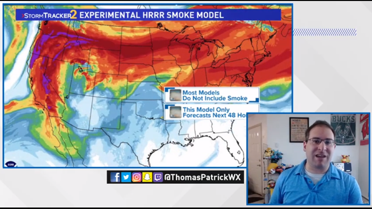
The forecasting is the most challenging thing when it comes to air quality and wildfire smoke. Most weather model do NOT include wildfires. Thus the effect the wildfires have on the surrounding regions isn't calculated into the model's outputs.
There is one model with an experimental version. The HRRR does include active wildfire and their smoke emissions. And it preformed very accurately during the week of poor air quality for the west coast. It was a fantastic tool to help meteorologists, like myself, to analyze and be able to produce an accurate local forecast.
But if you were looking at the default app on your phone for weather, the sky cover and temperatures would've been massively off, sometimes by more than 20 degrees too warm!
Seeing the accuracy of the new computer models leads to a high level of forecast confidence when analyzed. And that will prove to be very useful in future summers on the west coast where wildfires are part of the norm.
Weather Classroom is produced and broadcasted by KREM Meteorologist Thomas Patrick is you can watch and chat live on his Facebook page Thursdays at 1 p.m. Pacific Time.


