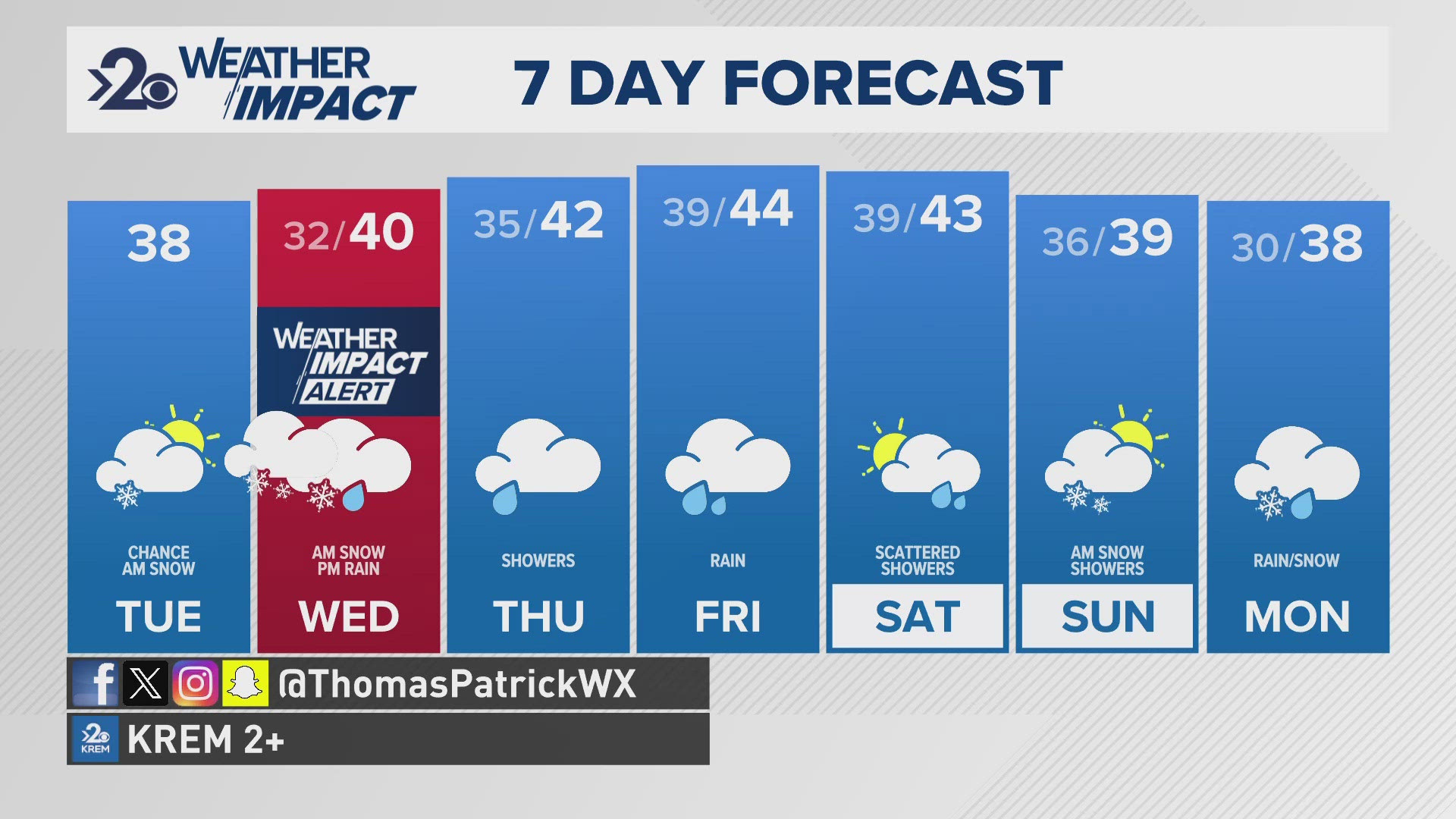
SPOKANE, Wash. — This morning, a dusting of snow has appears over Grant, Lincoln, and Adams Counties where that dusting of snow has starts to cover some roadways and highways. Meanwhile in Spokane, no so here (yet), but reports of black ice has been around since temperatures dropped to 28 degrees this morning. The light snow should not stick around all day, giving us a moment of clam before our main snowfall event this week...
Wednesday morning will feature moderate and wet snowfall throughout the region. It's a Weather Impact Alert Day for the region as Wednesday morning snow will make for a messy and slippery commute for drivers. A massive storm that strengthens off the Washington coast will result in heavy precipitation throughout the region. For us, snow arrives after around 4am in Spokane and goes through about 10 a.m. - noon. After noon it will switch back to rain for the rest of the day. For northern Washington, the snow lasts most of the day and may not change to rain at all, meaning greater snowfall totals overall.
For Spokane and Coeur d'Alene, about 1-2" of snow, a slight decrease from yesterday's forecast. The Palouse is also going to see a limiting 1" or so of snow. These areas are under a Winter Weather Advisories until 10am Wednesday. Meanwhile, the Idaho Panhandle and northeastern WA will range between 2-4". The Winter Weather Advisories here go until 10pm. North-central WA like Omak and Republic will get nearly 4-6" of snow. Winter Storm Warnings have already been issued for Okanogan and Ferry Counties in anticipation of the incoming snow.
The Cascades are a different story. Up to a foot of snow is expected and with snowfall rates of more than 1" per hour, it will be hard for crews to keep up with the snow. On top of the snow, wind will howl across the crest. Gusts of up to near 50 miles per hour will drop visibility to near zero at times. Blizzard Warnings are in place Tuesday afternoon to Wednesday morning for mountain passes in anticipation of the blowing snow and zero visibility at times.
As always, forecasts like this can change, especially with a snow-changing-to-rain style of event can make a big difference in snow totals. So be sure to stay tuned for any changes in the forecast over the next 48 hours.
-KREM 2 Meteorologist Thomas Patrick
Get the latest Weather Impact forecast and warnings on your mobile device. Download the KREM 2 app and turn on severe weather alerts.
About the KREM 2 Weather Team
- Jeremy LaGoo is the KREM 2 Chief Meteorologist, He joined KREM in October of 2020. You can watch Jeremy weeknights on KREM 2 News at 4, 5, 6, 10 and 11 p.m.
- Thomas Patrick is the Up with KREM meteorologist from 5-9 a.m. and noon. Thomas joined KREM in January 2019. Thomas is an AMS Certified Broadcast Meteorologist since 2015. He also serves as a KREM 2 weather and science reporter.
- Michelle Boss joined the KREM 2 weather team in 1999 and can be seen on the weekend evening forecast. She previously worked as a meteorologist at WEHT in Evansville, IN, and WOWT in Omaha, NE.
DOWNLOAD THE KREM SMARTPHONE APP
DOWNLOAD FOR IPHONE HERE | DOWNLOAD FOR ANDROID HERE
HOW TO ADD THE KREM+ APP TO YOUR STREAMING DEVICE
ROKU: Add the channel from the ROKU store or by searching for KREM in the Channel Store.
Fire TV: Search for "KREM" to find the free app to add to your account. Another option for Fire TV is to have the app delivered directly to your Fire TV through Amazon.
To report a typo or grammatical error, please email webspokane@krem.com.


