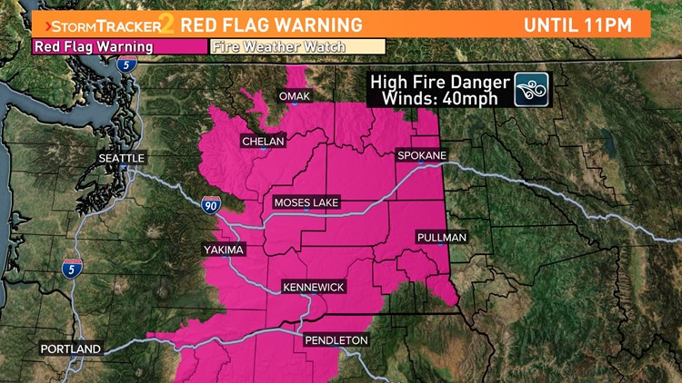
SPOKANE, Wash. — Fire danger is at high levels this Monday due to strong winds and dry conditions. This has prompted Red Flag Warnings for central and eastern Washington until 11 p.m. Monday.
Wind gusts have already topped 40-45 mph for portions of the Inland Northwest between Grant and Spokane counties. These winds, while not damaging on their own, could be the catalyst for rapid wildfire spread should any new fire spawn today.
Furthermore, conditions are very dry, with relative humidity around 10-20% locally.
This is all a result of a fast-moving and dry cold front passage that swept through the area early this morning. High temperatures will be down by a factor of 15 degrees, which highlights the strength of the cold front even though there was no rain or storms that came with it.
Quick-burning fuels like grass and sagebrush are extremely dry due to the weather conditions and would be most susceptible to a quickly developing wildfire today.
Forested and mountainous regions are not as high of a risk for two factors. One, it's still early season, so there is still sufficient soil moisture (though it's drying out quickly). And two, since the winds are southwesterly, the more north-to-south mountain ranges will experience slower wind speeds today.
The strongest winds will calm down after dark and should be tame by midnight tonight. Monday is the only day this week that's expecting winds this strong.