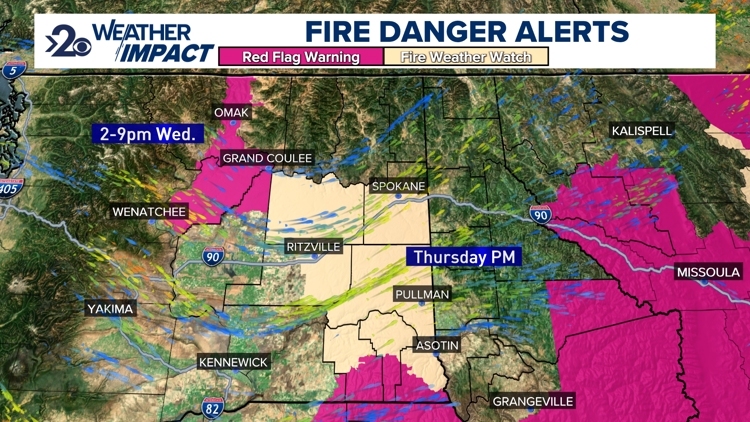
SPOKANE, Wash. — An approaching storm system will start to increase winds across the Inland Northwest. And the overall dry and windy weather means that some will be under threat of higher fire danger in the next 24 hours.
Red Flag Warnings have already been issued for the Okanogan Valley Wednesday from 2-9 p.m. as winds have already started to increase to 30-40mph today. But as a cold front passes through Eastern Washington tonight, winds will be stronger on Thursday. For now, Fire Weather Watches are in effect Thursday afternoon for Eastern Washington regions. This will be upgraded to a Red Flag Warning by the National Weather Service office in Spokane in a later update.
Winds will increase to 20mph tonight and then around 30mph Thursday morning. They'll remain around 20-25mph Thursday afternoon. But it's the afternoon hours when the humidity is lowest, and thus the fire danger is at its highest. In terms of elevated fire danger, this is marginal to issue Red Flag Warnings, i.e. it's the lowest possible threshold. Nonetheless, it's still important to get the word out that activities like campfires are a bad idea during the windy days and nights for the next day and a half.
When: 12-9 p.m. Thursday
Impact: Heightened fire danger due to winds up to 30mph.
Need to Know: Respect burn bans and avoid fire-related activities including campfires, etc.