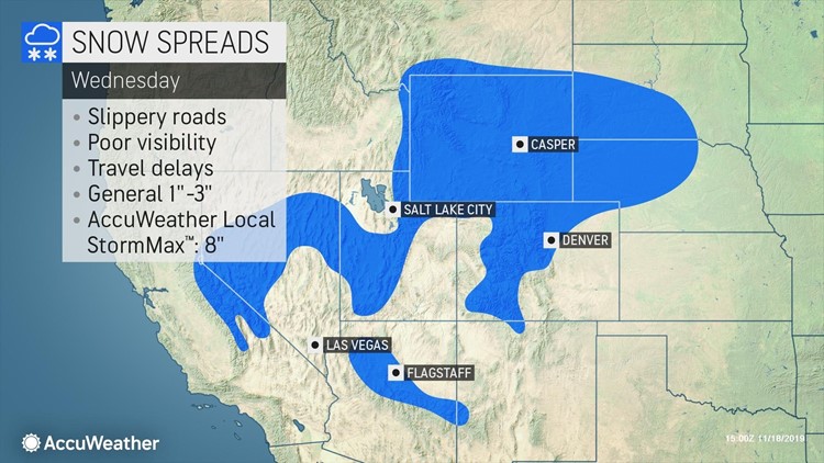
Part of the same storm set to bring beneficial rain to Southern California and the Southwestern states will break off and produce a swath of snow from the eastern slopes of the Rockies to the upper Great Lakes at midweek.

The storm is first forecast to bring snow to parts of the interior Southwest on Wednesday, where snowfall will not be limited to the higher elevations.
"Snow is likely to reach down to the valley floors of the Great Basin in central Nevada and parts of western and central Utah," AccuWeather Senior Meteorologist Brett Anderson said.

A general 1-3 inches is expected to fall at elevations of 5,000 feet or higher from the southern Sierra Nevada to the foothills of the Rockies and the Black Hills of South Dakota.
"An AccuWeather Local StormMax™ of 8 inches can fall over the high country of the southern Sierra Nevada, Wasatch Range and Rockies in Wyoming and Colorado," Anderson said.
Wet snow can mix in Wednesday night around Salt Lake City for a time. Little to no accumulation is expected.
Enough snow can fall in the Denver area from late Wednesday to Thursday to bring 1-3 inches on non-paved areas. The snow may also result in slippery roads and sidewalks in and around the Mile High City.
The same part of the Southwest storm will travel northeastward across the central and northern Plains to the upper Great Lakes during Wednesday night and Thursday.
While the bulk of the snow is forecast to bypass Minneapolis, a small, slippery accumulation can occur in the Twin Cities area by Thursday morning.

A general 1-3 inches (3-8 cm) of snow is forecast from northeastern South Dakota to northwestern Ontario. However, a pocket of 3-6 inches (8-15 cm) of snow with an AccuWeather Local StormMax™ of 8 inches (20 cm) can occur along the western and northern shores of Lake Superior.
While a blast of bitterly cold air is not expected to follow the snow, unlike that of late October and early November, temperatures are expected to dip low enough in the wake of the snowfall to cause any wet and slushy areas to freeze.
Nighttime lows are forecast to be in the teens and 20s F in the wake of the storm.
Motorists and pedestrians should be prepared for icy spots on untreated surfaces from the evening to the early morning hours in the wake of the storm later this week.

Download the free AccuWeather app to check the forecast in your area. Keep checking back on AccuWeather.com and stay tuned to the AccuWeather Network on DirecTV, Frontier and Verizon Fios.


