A winterlike pattern will continue to unfold across much of the eastern two-thirds of the nation into next week as a brutal one-two punch of bitterly cold air plunging into the United States will set the stage for another major storm.
A weak storm will first dive southward from Canada into the central U.S. this weekend as temperatures continue to nose dive, with freezing weather predicted to take aim nearly all the way to the Gulf Coast.
Snow will first spread across Montana and North Dakota later on Saturday then into South Dakota on Sunday.
By Sunday afternoon, some light snow may arrive in northern Nebraska, northwestern Iowa and southwestern Minnesota, before it could reach the Chicago area by late Sunday night.

Through Sunday night, the highest snowfall amounts will be confined to the highest elevations of the northern Rockies, where over a foot of snow is possible.
"A swath of 6 to as much as 12 inches of snow is likely through Montana and into far-western South Dakota," AccuWeather Meteorologist Brett Edwards said.
Farther south and east, less snowfall is expected, but a fresh blanket of snow can be anticipated in communities like Rapid City, South Dakota, and Cheyenne, Wyoming.
Motorists across parts of Interstates 94, 90, 80 and 25 are likely to endure delays throughout the weekend.
This storm will become more potent as it evolves over the central Plains and taps into moisture from the Gulf of Mexico early next week.

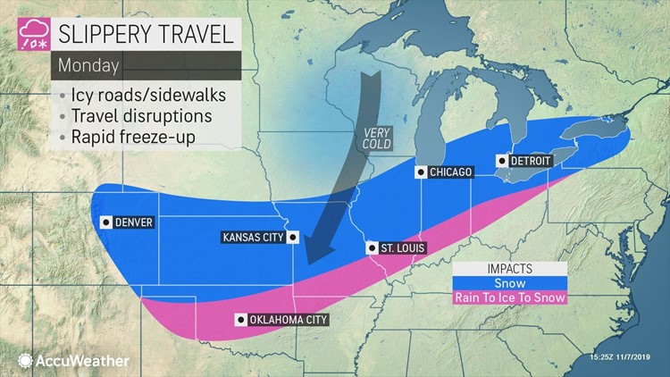
It may drag down enough Arctic air along with it to allow snow to break out across parts of Kansas and Oklahoma, and rain may mix with and change over to ice or snow as far south as northern Texas on Monday.
Generally, any snow accumulations are expected to be light in this zone, if accumulations occur at all. How quickly cold air catches up with the storm will determine whether accumulating snow can reach areas like southern Oklahoma and northern Texas.
"A rush of cold air will sharply drop temperatures behind the system Sunday night and Monday. Any lingering wet spots may rapidly freeze up," Edwards added.
Snow and a freeze-up could make travel difficult on roads, and icy conditions could impact flights arriving at or departing from major airport hubs like Kansas City, St. Louis and Oklahoma City.
The storm will also grow in size while it strengthens throughout the day on Monday. An extensive swath of snow will fall from the Plains to the mid-Mississippi Valley and Ohio valleys as well as across portions of the Great Lakes.
More significant snowfall totals, including enough to plow, could be possible in locations where precipitation is able to fall as snow most of the time.
Snow and rain are expected to expand into the Northeast, perhaps arriving as early as Monday afternoon and lasting into the day Tuesday. Precipitation across much of upstate New York and northern New England may start off as and continue as snow through the duration of the storm.
Farther south, many locations will experience rain first.
"The intense cold following the storm may also allow for the New England coast and the rest of the Northeast to change over to wintry precipitation," Edwards said.
The exact track of the storm and how much it intensifies will be crucial in determining how much snow falls in the eastern third of the country.
Download the free AccuWeather app to get the latest updates on the storm and how it will affect your area. Keep checking back on AccuWeather.com and stay tuned to the AccuWeather Network on DirecTV, Frontier and Verizon Fios.


