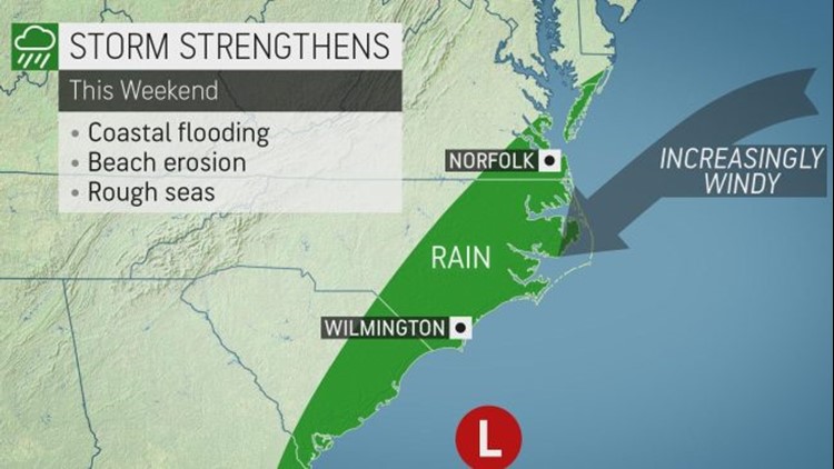
A storm will bring gusty winds, drenching rain and above-normal tides to part of the United States' East Coast this weekend -- but how far north might these conditions spread?
The storm will spread drenching rain across the Deep South late this week before it is expected to strengthen along the Atlantic coast this weekend.

How quickly the storm strengthens will determine how far north along the mid-Atlantic coast rain may spread.
At this time, it appears steady, heavy rain may struggle to spread any farther north than southeastern Virginia and southern Maryland. However, should the storm strengthen significantly and hug the coast instead of moving out to sea, rain may spread much farther north.
"Regardless, clouds will spread northward along the coast and there could be a dash or two of rain as far north as New Jersey," Randy Adkins, AccuWeather senior meteorologist, said.
The combination of northeast winds and rough surf will lead to coastal flooding and beach erosion. The worst conditions are likely in eastern North Carolina and southeastern Virginia. Northeast winds averaging 25-50 mph are forecast in northeastern North Carolina. There is the potential for gusts to 65 mph on the Outer Banks.

In one scenario, wind-swept rain would advance northward across Delaware, New Jersey, southeastern New York state and coastal New England this weekend.
The storm is expected to strengthen enough to generate gusty winds throughout the mid-Atlantic and southern New England coasts.
The stiff winds will spread northward along the mid-Atlantic coast during Saturday and Saturday night and reach southern New England on Sunday.
"AccuWeather RealFeel® Temperatures will plummet to 10-20 degrees lower than the actual temperature at the peak of the winds," AccuWeather Senior Meteorologist Brett Anderson said.
"The conditions will create a high level of discomfort and hypothermia risk for those not properly dressed," Anderson said.
For example, around Atlantic City, New Jersey, on Saturday and Sunday, even though actual temperatures may peak in the middle 40s, RealFeel Temperatures are likely to hover in the upper 20s to lower 30s much of the day. Those spending time outdoors in the coastal locations will need to dress accordingly.
The stiff winds will also push ocean water toward the coast.
Communities in eastern North Carolina and southeastern Virginia that are prone to coastal flooding during nor'easters or tropical storms should expect problems this weekend. This includes Hampton Roads, Virginia, and Rodanthe, North Carolina.
If the storm tracks farther to the north, then significant wind, beach erosion and coastal flooding can progress northward to the upper mid-Atlantic coast and eastern New England as well. These areas are likely to experience minor problems, even if the storm stays south and/or at sea.
Meanwhile, farther inland, an area of high pressure is forecast to hold its ground. This fair weather system will generally promote dry, sunny and relatively calm conditions from much of the southern Appalachians to northern New England. Despite the clear conditions, the nights will be quite cold and the days chilly at best.
A lack of a significant atmospheric traffic jam near Greenland should prevent the storm from becoming a bomb cyclone, tracking much farther north and stalling. Such a scenario would replace sunshine with heavy snow across the interior Northeast and a wintry mix near the coast this weekend.
A second storm may follow close behind and brew over the Gulf of Mexico early next week. That storm, while much weaker, may have a pathway to bring rain to much of the coastal mid-Atlantic and New England with perhaps a bit of snow across the interior Northeast.
Download the free AccuWeather app to get the latest updates on the storm and how it might affect your area. Keep checking back on AccuWeather.com and stay tuned to the AccuWeather Network on DirecTV, Frontier and Verizon Fios.


