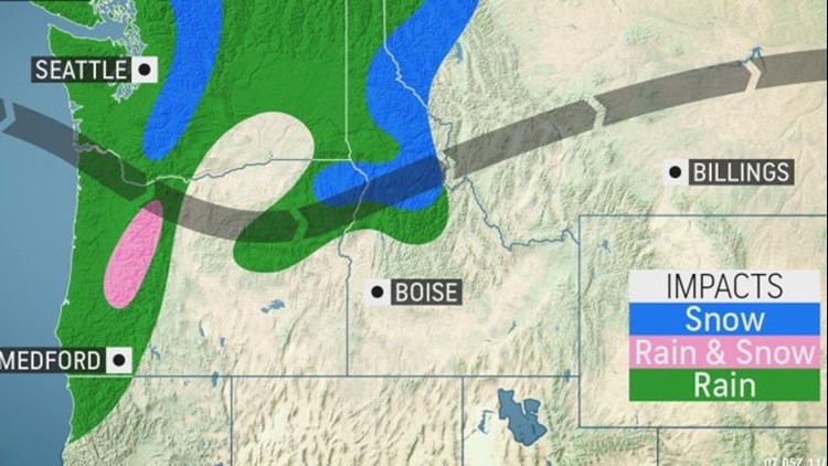
The first in a parade of storms for the northwestern United States will bring rain and mountain snow over the next couple of days, but will this stormy pattern continue throughout November?
A storm system will move into western Canada and the northwestern U.S. on Friday.
As the storm pushes inland, areas of rain will spread across the Northwest. Most of the rain will be limited to the Cascade and Rocky mountains while inland valleys will remain largely dry.
Precipitation is expected to fall as snow in the highest elevations of these mountain ranges in Washington, Idaho and northwestern Montana.
Rain will gradually change over to snow in the higher elevations of the Cascades in Oregon by Friday afternoon as colder air filters into the region and snow levels drop.

With snow levels expected to drop between 6,000 and 7,000 feet in the Pacific Northwest, accumulating snow will remain above mountain pass.
As the storm continues to push inland through Friday night, rain and mountain snow will gradually taper off across Washington and Oregon.
Rain and high-elevation snow is expected to continue in Idaho and western Montana through the overnight period.
High-elevation snow will spread south into Wyoming and northern Colorado throughout the day on Saturday as the storm sinks south over the Rocky Mountains. Accumulating snow is expected to be largely limited to the highest peaks.
An area of high pressure will follow quickly behind the storm system and promote mainly dry conditions to the Northwest to start the weekend.
As the high follows the storm system tracking along the Rockies it will increase winds in parts of California, reigniting the fire threat across the area.
On Saturday, another storm system is forecast to bring rain and interior snow to British Columbia. Some of this rain will reach far enough south to dampen the Olympic Peninsula and Puget Sound regions.

Rain can spread farther south along the Washington coast on Sunday as the area of high pressure moves toward the Great Basin and the storm system over British Columbia moves inland.
This will not be the last in the parade of storms for the Northwest. Another system is forecast to follow quickly behind and bring another round of rain and mountain snow to the region early next week.
Once again, valleys look to remain largely dry, but snow levels may drop enough for some accumulations in the highest passes of the Cascades.
A quiet weather pattern looks to set up through the end of next week. A storm system over the Southwest will push high pressure into the Northwest. This will keep the storm track north into Canada.
Outside of a couple of quick storms, the Northwest may remain largely dry through the rest of November. However, the pattern may flip in the beginning of December.
"A large storm system developing over the Gulf of Alaska and along the West coast is likely to bring a stormier pattern through the Northwest and northern Rockies," stated AccuWeather Long-Range Meteorologist Jack Boston, "with the potential for heavy mountain snowfalls and soaking to heavy rain and wind in the lower elevations during the first week of December."

Download the free AccuWeather app to check the forecast in your area. Keep checking back on AccuWeather.com and stay tuned to the AccuWeather Network on DirecTV, Frontier and Verizon Fios.


